West Wittering
West Sussex
Type:Village
Cakeham Road, West Wittering, Chichester, West Sussex

West Sussex
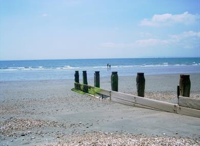
West Wittering is situated on the western coast of the Selsey Peninsula and has a large expanse of firm sand, ideal for children to play and safe for bathing. Portsmouth and the isle of Wight can be seen across the water. The first invading Saxons are thought to have landed here.
The village proper lies a little way inland and has a fine church of Norman origin, but is mostly thirteenth century as it nowstands. A tomb-slab carved with a pastoral staff is believed to be that opf a boy-bishop. On the way to East Wittering is Cakeham, now a farm, but anciently a palace of the Bishop's of Chichester. It dates in part from the thirteenth century and has a Tudor outlook tower of brick.
Situated just 3 miles away from Chichester Cathedral and just over five miles away from Staunton Country Park, West Wittering is an ideal destination.
The beach offers wonderful views of Chichester Harbour and the South Downs beyond, the natural and unspoilt sandy beach of West Wittering has been a favourite destination for a family day out for generations. Escape to this idyllic destination for an early summer retreat and immerse yourself in the beauty that surrounds you.
See here for Accommodation in Sussex.
West Wittering is situated on the western coast of the Selsey Peninsula and has a large…
The beach provides sandy beach at low tide, pebbly at high tide. Ideal for a family day…
Chichester Harbour is an Area of Outstanding Natural Beauty including the harbour and…
Three attractions in one!. Tropical butterflies, exotic birds and theme garden. There is…
The Hayling Seaside Railway runs from Beachlands to Eastoke - fun for all.
Real seaside fun for all the family. Funlands Amusement Park is situated right next to…
Hayling Island has over 3 miles of beaches along the seafront facing the Solent and many…
Row the only Cornish Pilot Gigs in Hampshire! Six-oared boats providing safe, stable…
There are more than 4000 stars and other celestial objects in the skies of the South…
The Spring has a broad programme of entertainment including theatre shows, music, comedy…
Bishop's Palace Gardens is situated within the City Walls, next to the Cathedral. And it…
In the heart of Chichester, a magnificent Cathedral with treasures ranging from medieval…
Pallant House Gallery is one of the UK’s most distinctive public galleries, exploring new…
Visit the impressive Victorian buildings, which showcase the marvels of Victorian…
Chichester Festival Theatre creates inspiring experiences and exceptional stories that…

© Visit South East England 2026. All Rights Reserved